10:00 am ET Wednesday June 27, 2018
There is no doubt it will be getting hot across the Northeast and Mid-Atlantic this weekend into early next week. This has been a week of ups and downs with models showing, in some cases extreme temperatures.
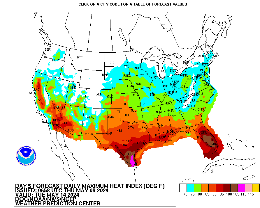
While the heat is coming into the Northeast, lets no forget that a lot of the country from the Plains to the South will experience extreme temperatures with very high heat indexes. I noticed that the modeling is predicting dew points in the upper 60s to upper 70s in some areas. Combine that with the heat, we are talking HEAT INDEX well into the 100s and even in the dangerous category.
Below is the NOAA image showing the maximum heat index for Sunday. Notice many areas are in the 105-110 degree F category which is not good if you are outside. For specific temperatures I refer you to your Apps and local weather folks.
Related Links:
Heat Index Chart
Heat Index Maps
Hazard Maps

Heat Index for Sunday

Eastern US Highs Monday

GFS Highs Monday
4:00 pm ET Tuesday June 26, 2018:
So the GFS continues to back off the Heat and now we have another issue and that is the potential for a coastal storm. The NAO is going negative and that usually means a storm will some how find it’s way to the East Coast. GFS has a front coming through Tuesday, stalling it and a storm develops near The Dalmarva. The implications of that means rainy and cooler weather, not a heat wave if that is correct. My guess is probably not. The ECMWF has the coastal storm way out that but it’s backing southwest. Both models are having a hard time figuring it all out. In the meantime, it will get hot this weekend into Monday with highs int he low to mid 90s with high heat index values making it feel horrible outside.

GFS Temps for Monday

GFS Surface Map for Tuesday
7:00 am Tuesday June 26, 2018 Update:
GFS has backed off on the extreme the heat and has adjusted to what I think is a better forecast between the ECMWF and GFS of Low to Mid 90’s for highs prior to the 4th of July. One of the issues as to why the GFS has backed off the heat is the potential coastal storm. As mentioned last night, the trough splits in the Atlantic and comes back southwest stirring up a storm in the Atlantic. If that solution is correct, it knocks down the ridge and changes the wind direction so temperatures end up in the low to mid 90s not 100s as the GFS was showing. I think overall that was way too extreme on the model especially during a soggy 90 days running up to the heat coming. What I mean by that some places are running 100% to 200% above normal rainfall the last 90 days. Typical heatwaves come with dry weather prior not soggy weather. Also for the major cities along the I-95 corridor to get extremely hot, you really need to have the winds coming from the west, downsloping off the Appalachians to add those few extra degrees. I just don’t see that wind component.
Now don’t get me wrong, the period from Saturday to Tuesday will be hot with high humidity making it feel oppressive outside. The HEAT INDEX shows temperatures outside feeling like 100 degrees so make sure you hydrate!

 Get Your Weather on Echo!

GFS 2m Temperatures for Sunday Afternoon

Monday Morning Surface Map Showing the Storm Off the Coast
Monday Evening, June 25, 2018
So I was curious as to why we are seeing a difference between the two models on the heat coming East. As you know, the GFS has been on the record extreme heat while the ECMWF has been showing normal heat for early July. You can see clearly in the animations that the ECMWF splits the trough and brings it back southeast, knocking down the ridge across the Northeast thus one day of heat then back to near normal heat for early July. The GFS keeps the ridge strong through the period and knocks it down around the 4th as the same feature comes in from the east. Both generally has the same idea that the tough splits over the Atlantic and comes back southeast but timing and strength of that trough makes a big difference between 100 degrees or 90 degrees F in New York city as an exmaple. I still thjnk the answer lies between the two models as temperatures are in the low to mid 90s from Sunday through Tuesday.


Monday Morning, June 25, 2018
So the hype has started based on the GFS extreme heat for next week. While I contend it will get hot as another surge of heat comes out of the Plains into the East, the GFS model looks way to hot while the ECMWF model looks a bit too cool. The answer as I see it, lies somewhere between the two models with highs in the low to mid 90s. I would us extreme caution when throwing out temperatures in the 100s right now for areas north of Maryland and south Jersey.
So what do we know today.
- The heat starts next weekend and probably lasts through July 4th. The storm the forms probably does so prior to the heat coming.
- Sunday through Tuesday looks like the hottest days with highs in the low to mid 90s.
- GFS model seems to be on the extreme of things with highs in the 100s which typically has to happen with downsloping and dry weather prior.
- The heat is coming with high dew points which means dangerous HEAT INDEX.
- Just to put things in perspective. Highest ever NYC 106 and Philly 106. GFS predicting 106 NYC and 107 Philly. GFS way to hot!
ECMWF Temperatures for Monday July 2.

GFS Temperatures for Monday July 2

ORIGINAL POST 6/24/2018
The sure will be busy by the time we get to next week and there are some issues at had. The first one is the heat coming East. GFS model seems to be going toward very hot weather with high swell into the 90s and low 100s, while the ECMWF is saying no, just upper 80s and low to mid 90s. I am leaning toward the ECMWF on this one simply because the GFS solution is way too extreme and given the so ggy ground, it will take a lot to get to 100 degrees F. especially away from the Big Cities as shown on the map. In addition, the dew points are predicted to be in the upper 60s to mid 70s which combined with that type of heat would mean extremely dangerous heat indexes. In any case, it will get hot for a couple of days prior to July 4th.
The other issue is a storm along the coast or tropical troubles. I have been talking about the storm potential prior to July 4th since releasing my 30-day forecast. I see now that ECMWF is showing a storm developing off the Southeast that eventually comes back under the heat into the southern Appalachians. The solution is probably not correct as of yet, but I still think that some storm is developing along the East coast prior to the 4th. If it happens to be closer to the mid-Atlantic, all bets are off with major heat in the big cities as the air mass will be more off the ocean and may even backdoor cold front.
So a lot is on the table as we approach the holiday.
ECMWF map showing the storm off the Carolina coast

Please Share My Blog to all your friends:
Like this:
Like Loading...
