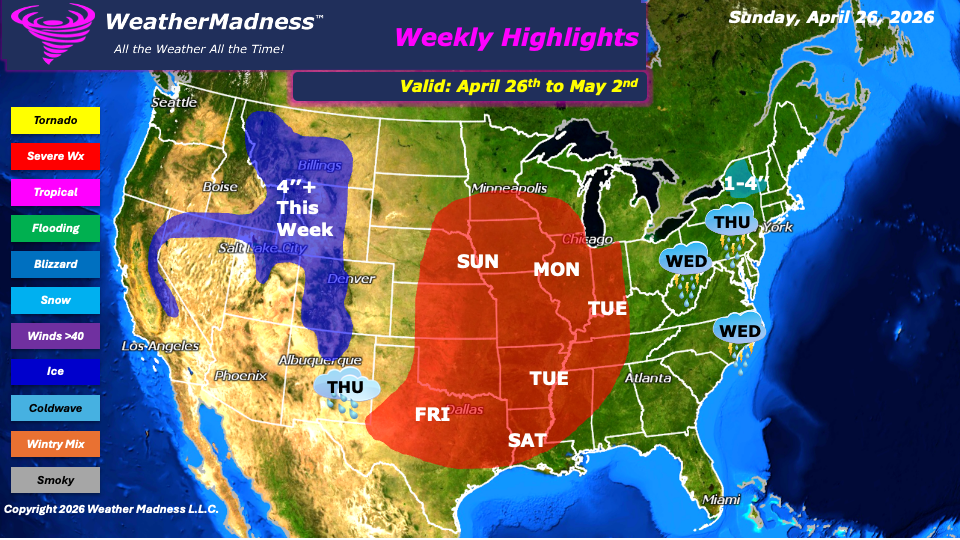
This week’s weather will focus a dynamic system that will drive conditions beginning Sunday, when severe weather is expected to develop across the Plains. This threat will shift into the Midwest on Monday, where all hazards will be in play, including a heightened risk for tornadoes. By Tuesday, the focus for strong to severe storms transitions into the Ohio and Mississippi Valley, maintaining a broad corridor of unsettled and potentially dangerous conditions.
As the system progresses eastward, attention turns to the Northeast and Mid-Atlantic on Wednesday into Thursday. Showers and thunderstorms moving into the region may bring the potential for localized severe weather. Meanwhile, the Four Corners region will see increasing chances for showers by Thursday, adding to a generally unsettled pattern across much of the country. By Friday, severe weather is expected to redevelop across the southern Plains and into Texas, continuing the week’s active trend.
Late in the week, a notable shift to colder conditions on the backside of the eastern system may bring accumulating snowfall to portions of upstate New York into Vermont. These areas could see between one and four inches of snow from Friday into early Saturday, while rain impacts much of the broader Northeast. At the same time, additional rounds of severe weather are anticipated on Saturday across Texas and the lower Mississippi Valley extending toward the Gulf states.
Out west, snow will be a recurring theme in the Rockies and Sierra Nevada, where some locations may receive more than four inches of accumulation over the course of the week. Temperatures across much of the United States will remain relatively mild overall, though out west will start on the cooler side before gradually warming by midweek. With repeated rounds of rainfall expected, there is also an increased risk for localized flooding. Areas of concern include the Plains, Midwest, Great Lakes, Mississippi Valley, and parts of the Northeast. Residents in these regions should remain alert for rapidly changing conditions and potential flood advisories as the week progresses.
By Matt K.
Forecaster