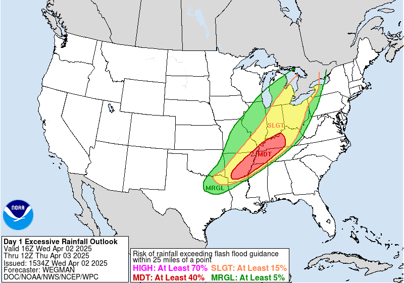
Tropical Low will Bring Heavy Rains Front Page Rainfall Severe Weather Pro Top Story Tropical Weather Weather Madness Pro Discussions Oct 9, 2023 Weather Madness 0 Comment Low pressure developing in the southern Gulf of Mexico will head north then turn northeast Wednesday into Wednesday night. That system will be close to tropical depression or even tropical storm status but most likely, will be just a tropical low that moves through the Gulf. Despite the status, the storm will bring heavy rains from south Texas through the Gulf coast into southern Georgia and northern Florida. Rainfall of 1-5 inches will occur which can cause flooding problems. Severe storms will move across central Florida late Wednesday and the storms can bring damaging winds and perhaps a few tornadoes. If the storm is able to intensify, winds will be another issue but that depends on how strong the storm becomes.
Tri-State Flooding Could Get Serious. NYC in the Center! East Coast Front Page Rainfall Severe Weather Pro Top Story Weather Madness Pro Discussions Sep 28, 2023 Weather Madness 0 Comment A storm will form off the Mid-Atlantic coast Friday into Friday night. That storm will bring moisture into the Tri-State area which will result in flooding. The rainfall will be 1-6 inches into Saturday morning. The result of that much rains mean road flooding, delays and even subway flooding in NYC. NYC may see 4-5 inches of rain in 12 hours. Many areas of northern New Jersey into Connecticut and Long Island will see over 3 inches of rain in a short period of time. Thunder and lightning will ocupany the heavy rains.
Updated: Tropical System will Bring Heavy Rains and Flooding this Weekend! East Coast Front Page Rainfall Top Story Weather Madness Pro Discussions Sep 18, 2023 Weather Madness 2 Comment Friday 9/22/23 – The storm is developing this morning and will most likely become tropical storm or subtropical storm Ophelia. The track will track the system over eastern North Carolina to Baltimore where the system will just unwind Monday. The blocking pattern is going to cause the system to just sit over the Mid-Atlantic through early next week. Heavy rains of 1-6 inches will occur across eastern North Carolina into eastern Virginia. A tornado threat will occur as well over that area as thunderstorms roll into the area tonight and Saturday. Winds along the coast will be gust 40-70 mph from Wilmington, NC to Atlantic City Nj. A minor storm surge will cause waves to come up to the bulkheads of the beaches. Wednesday 9/20/23 – The blocking pattern is leading to the tropical system being forced out into the Atlantic after coming north to about Virginia. This means the heaviest of the rains will hug the coast from North Carolina to southern New England while inland the rains will be light to moderate or just soaking as a better way to explain it. Winds along the coast from South Carolina to southern New England will be strong with gusts to 50 mph Friday night into Saturday. Another tropical system will develop near the Southeast coast Friday. That system will bring very heavy rains from eastern North Carolina through eastern Pennsylvania and southern New England. Areas from The Delmarva to eastern North Carolina can see up to 6 inches of rain. Winds along the North Carolina and Southeast Virginia coast will be gusting up to 50 mph. Moderate to heavy rains will also impact the Piedmont and Appalachians. The storm will move north and be located over south-central Pennsylvania Sunday morning then weaken to just a quick moving low center Sunday afternoon.
Heat Builds and Expands East Front Page Rainfall Top Story Weather Madness Pro Discussions Aug 15, 2023 Weather Madness 1 Comment A late season heatwave will build in the Plains this week and eventually will expand into the eastern part of the country by next week. For many, this will be a prolonged period of dry and hot weather that will last for at least 10 days. The Plains will see highs in the 100s and that area of upper 90s and 100s will expand into the Ohio and Tennessee Valleys over the weekend into early next week. The I-95 corridor will also see highs in the upper 90s and 100s early next week. It will take a cold front to break the heat later next week.