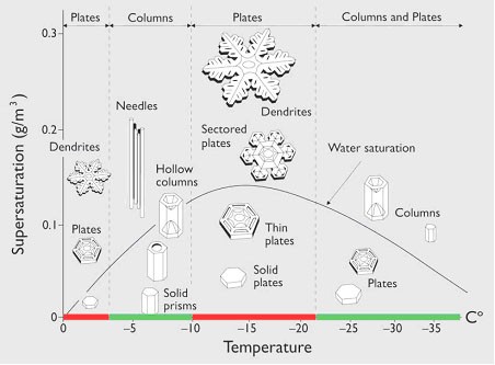
The current storm has under achieved snow amounts and basically that was due to the coldness and dry air that the snow developed in. The size of the snowflakes really mattered in this storm and because they were smaller, the amounts were not as much as I expected. You can see on the chart below how temperature and saturation impact the size of snow dendrils.
The pattern remains such that a powerful storm should develop along the East Coast. I know the models have been going all over the place with the storm, showing it as a 965mb storm with 20-30 inches of snow, to a suppressed weaker storm across the South. With the NAO negative i.e. blocking pattern along with the +PNA and -AO should all lead to a pattern where a storm intensifies along the East Coast, History has shown that the models doe poorly until 5 days from the storm when they start showing the true magnitude of what can happen. If by Tuesday afternoon, the storm is not shown on the GFS and ECMWF, then is not coming and just light snow and ice will impact areas from Texas to Virginia. Below is an image of what could happen this weekend.
