Rockies Snowstorm Discussion
A significant late-season snowstorm is impacting the Front Range of the Rockies, extending from Wyoming through Colorado and into the adjacent High Plains.
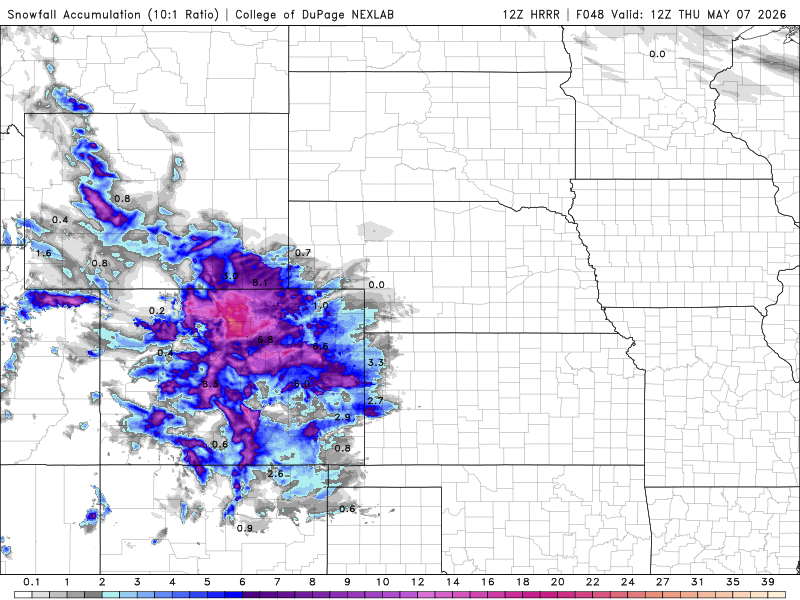
The heaviest snowfall will be focused along the Interstate 25 corridor, where 8 inches or more is expected from tonight into Wednesday. Snow will also spread east into parts of Kansas and Nebraska, with lighter accumulations, and may extend south into northern New Mexico and even parts of the Oklahoma Panhandle.
Impacts
This will be a heavy, wet snow, which increases the risk for:
- Tree damage
- Power outages due to weighed-down lines
- Slushy, hazardous road conditions
Travel will be especially difficult:
- Interstate 70 through the mountains, including near the Eisenhower Tunnel, where conditions may become treacherous
- Interstate 25, where roads may turn wet and slushy, reducing traction and visibility
Higher elevations in the mountains and foothills will also see significant snowfall, further complicating travel.
Bottom Line
- Heavy snow WY → CO → High Plains
- 8+ inches along I-25 corridor
- Snow spreading into KS, NE, NM, and OK Panhandle
- Heavy, wet snow → tree damage & power outages
- Hazardous travel on I-70 and I-25
This is a high-impact spring snowstorm, with both travel and infrastructure concerns due to the weight and intensity of the snow.